
Your web browser is no longer supported. To improve your experience update it here
Australian weather forecast
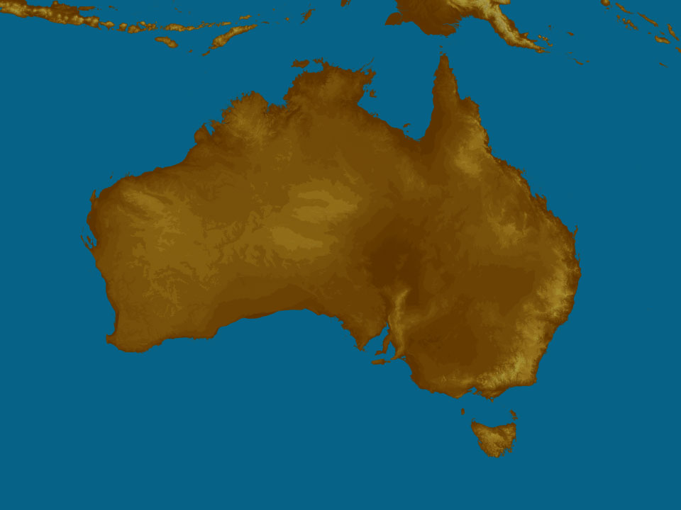
National weather
Rain Radar map
13:10 AEDT13:15 AEDT13:20 AEDT13:25 AEDT13:30 AEDT13:35 AEDT13:40 AEDT

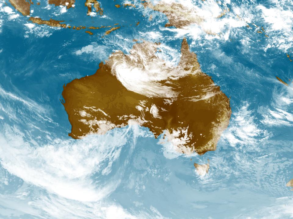
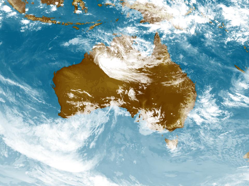
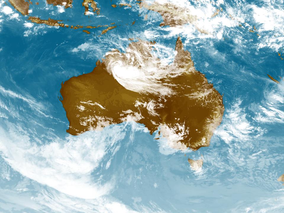
Weather Satellite
12:30 AEDT12:40 AEDT12:50 AEDT13:00 AEDT13:10 AEDT13:20 AEDT13:30 AEDT


Synoptic weather chart
View national synoptic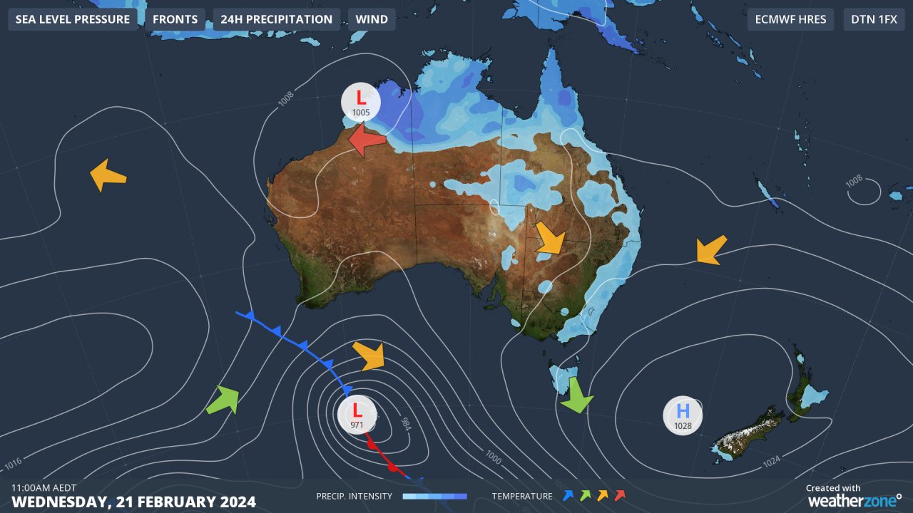
Tuesday 12:02 EST
Rain, storms & showers will persist across the tropics, heaviest in the northwest due to a low (ex-Tropical Cyclone Lincoln). Showers & storms across eastern Australia, aided by humid easterly winds. A high will keep elsewhere dry whilst directing hot winds across WA & inland SA.
Issued Tuesday 23:02 EST
Weather warnings
Detailed Severe Thunderstorm Warning (Heavy Rainfall) for parts of Wollondilly/Wingecarribee, Greater Wollongong and Sydney areas
Australian Government Bureau of Meteorology New South Wales TOP PRIORITY FOR IMMEDIATE BROADCAST Detailed Severe Thunderstorm Warning for Heavy Rainfall for parts of Wollondilly/Wingecarribee, Greater Wollongong and Sydney areas. Issued at 1:37 pm Tuesday, 20 February 2024. HEAVY RAINFALL for the following areas: Sydney, Wollondilly/Wingecarribee and Greater Wollongong The Bureau of Meteorology warns that, at 1:10 pm, a severe thunderstorm likely to produce heavy rainfall that may lead to flash flooding was detected near waters off Stanwell Park, Helensburgh, Stanwell Park and waters off Thirroul. This thunderstorm is moving towards the west. It is forecast to affect Bulli, Darkes Forest and Thirroul by 1:25 pm and Lake Cataract by 1:40 pm. The State Emergency Service advises that people should: * Keep clear of creeks and storm drains. * Don't walk, ride your bike or drive through flood water. * If you are trapped by flash flooding, seek refuge in the highest available place and ring 000 if you need rescue. * Unplug computers and appliances. * Avoid using the phone during the storm. * Stay indoors away from windows, and keep children and pets indoors as well. * For emergency help in floods and storms, ring the SES (NSW and ACT) on 132 500. A more general severe thunderstorm warning is also current for parts of the Metropolitan and Illawarra districts. The next warning is due to be issued by 2:10 pm. Warnings are also available through TV and Radio broadcasts, the Bureau's website at www.bom.gov.au or call 1300 659 210. The Bureau and State Emergency Service would appreciate warnings being broadcast regularly.Severe Thunderstorm Warning (Heavy Rainfall) for parts of Metropolitan and Illawarra
Australian Government Bureau of Meteorology New South Wales TOP PRIORITY FOR IMMEDIATE BROADCAST Severe Thunderstorm Warning for Heavy Rainfall for parts of Metropolitan and Illawarra Forecast Districts. Issued at 1:33 pm Tuesday, 20 February 2024. Heavy rainfall near Woolongong and Southern Sydney. Weather Situation a coastal trough and onshore flow is resulting in slow-moving showers and thunderstorms into the Sydney and Illawarra coasts this afternoon. HEAVY RAINFALL for the following areas: Metropolitan and Illawarra Severe thunderstorms are likely to produce heavy rainfall that may lead to flash flooding in the warning area over the next several hours. Locations which may be affected include Wollongong, Campbelltown, Bulli, Port Kembla, Albion Park and Kiama. The State Emergency Service advises that people should: * Keep clear of creeks and storm drains. * Don't walk, ride your bike or drive through flood water. * If you are trapped by flash flooding, seek refuge in the highest available place and ring 000 if you need rescue. * Be aware that run-off from rainfall in fire affected areas may behave differently and be more rapid. It may also contain debris such as ash, soil, trees and rocks. * After bushfires, heavy rain and the loss of foliage can make the ground soft and heavy, leading to a greater chance of landslides. * Unplug computers and appliances. * Avoid using the phone during the storm. * Stay indoors away from windows, and keep children and pets indoors as well. * Stay vigilant and monitor conditions. Note that the landscape may have changed following bushfires. * For emergency help in floods and storms, ring the SES (NSW and ACT) on 132 500. The next warning is due to be issued by 4:35 pm. Warnings are also available through TV and Radio broadcasts, the Bureau's website at www.bom.gov.au or call 1300 659 210. The Bureau and State Emergency Service would appreciate warnings being broadcast regularly.Major Flood Warning For The Nicholson River
Australian Government Bureau of Meteorology, Queensland Major Flood Warning For The Nicholson River Issued at 12:04 PM EST on Tuesday 20 February 2024 Flood Warning Number: 21 MAJOR FLOOD PEAK LIKELY OCCURRING AT BURKETOWN AIRSTRIP River levels remain elevated across the Nicholson River catchment following recent rainfall. A flood peak around the major flood level is likely to be occurring along the Albert River at Burketown Airstrip, lower than the flood peak experienced earlier this month. An isolated 60 mm was recorded in the 24 hours to 9:00 am Tuesday. Showers and possible thunderstorms are forecast for the next few days, however widespread significant rainfall is not expected. The situation is being closely monitored and warnings will be updated as required. Nicholson and Gregory Rivers: Along the Nicholson River, river levels around Doomadgee are easing. River level rises and moderate to major flooding are estimated to be occurring downstream at Escott Station. Minor flooding is occurring along the Gregory River at Gregory Downs. No river level observations are available along the Albert River at Burketown Airstrip, however the river level is expected to be peaking around the major flood level (6.00 m). The river level is likely to remain around the major flood level (6.00 m) for the remainder of Tuesday and into Wednesday. Flood Safety Advice: Remember: If it's flooded, forget it. For flood emergency assistance contact the SES on 132 500. For life threatening emergencies, call Triple Zero (000) immediately.} Current emergency information is available at www.qld.gov.au/alerts Next issue: The next warning will be issued by 01:00 pm EST on Wednesday 21 February 2024. Latest River Heights: Gregory R at Riversleigh TM,2.25,Steady,11:00 AM TUE 20/02/24 Gregory R at Gregory Downs TM,5.47,Steady,11:00 AM TUE 20/02/24 Burketown Tide TM,5.02,Steady,11:35 AM TUE 20/02/24 Leichhardt R at Doughboy Ck TM,1.69,Steady,11:00 AM TUE 20/02/24 Leichhardt R at Julius Dam TM,0.19,Steady,11:00 AM TUE 20/02/24 Leichhardt R at Miranda Creek TM,2.68,Steady,11:00 AM TUE 20/02/24 Gunpowder Ck at Gunpowder TM,1.87,Steady,11:00 AM TUE 20/02/24 Leichhardt R at Floraville TM,4.17,Steady,11:00 AM TUE 20/02/24 This advice is also available by dialling 1300 659 210. Warning, rainfall and river information are available at www.bom.gov.au/qld/flood. The latest weather forecast is available at www.bom.gov.au/qld/forecasts.Minor Flood Warning For The Daly River
Australian Government Bureau of Meteorology, Northern Territory Minor Flood Warning For The Daly River Issued at 11:32 AM CST on Tuesday 20 February 2024 Flood Warning Number: 6 MINOR FLOODING OCCURRING AT DALY RIVER POLICE STATION Rainfall totals of up to 35 mm have been recorded across the Daly River catchment in the 24 hours to 9:00 am Tuesday. The catchments are wet, and many river and creek levels remain elevated. Minor flooding is occurring at Daly River Police Station, where a peak is likely during today. Showers and storms are forecast for the next few days, which may cause some isolated renewed river level rises. Lower Daly River: Minor flooding is occurring along the Lower Daly River. The Daly River Police Station is currently at 12.96 metres and approaching a peak, above the minor flood level (12.60 m). The Daly River Police Station is likely to peak below 13.00 metres today, below the moderate flood level (13.10 m). The Daly River Police Station is expected to remain above the minor flood level (12.60 m) for the next few days. Daly River above Douglas River: Cancellation Flood Safety Advice: The Northern Territory Emergency Service advises that people should: Stay away from flooded drains, rivers, streams and waterways. Prepare for flooding and move away while safe to do so. Don't drive into floodwaters.} For emergency help in floods, storms and cyclones call 132 500. Emergency information is available at www.securent.nt.gov.au . The latest road conditions are available at www.roadreport.nt.gov.au . Next issue: The next warning will be issued by 12:00 pm CST on Wednesday 21 February 2024. Latest River Heights: Daly River at Dorisvale Crossing,12.84,Falling,10:45 AM TUE 20/02/24 Douglas River at Douglas Crossing,4.25,Falling,11:00 AM TUE 20/02/24 Daly River at Beeboom Crossing,14.72,Falling,09:00 AM TUE 20/02/24 Daly River at Mount Nancar,14.95,Steady,11:15 AM TUE 20/02/24 Daly River at Daly River Police Station,12.96,Steady,10:45 AM TUE 20/02/24 This advice is also available by dialling 1300 659 210. Warning, rainfall and river information are available at www.bom.gov.au/nt/flood. The latest weather forecast is available at www.bom.gov.au/nt/forecasts.Strong Wind Warning for North Kimberley Coast
Australian Government Bureau of Meteorology Western Australia Marine Wind Warning Summary for Western Australia Issued at 10:00 AM WST on Tuesday 20 February 2024 for the period until midnight WST Wednesday 21 February 2024 Wind Warnings for Tuesday 20 February Strong Wind Warning for the following areas: North Kimberley Coast Wind Warnings for Wednesday 21 February Strong Wind Warning for the following areas: North Kimberley Coast, West Kimberley Coast, Ningaloo Coast and Gascoyne Coast The next marine wind warning summary will be issued by 4:00 pm WST Tuesday. ================================================================================ Check the latest Coastal Waters Forecast or Local Waters Forecast at http://www.bom.gov.au/wa/forecasts/map.shtml for information on wind, wave and weather conditions for these coastal zones. ================================================================================Moderate Flood Warning For The Diamantina River
Australian Government Bureau of Meteorology, Queensland Moderate Flood Warning For The Diamantina River Issued at 11:33 AM EST on Tuesday 20 February 2024 Flood Warning Number: 40 BIRDSVILLE STEADY AT A PROLONGED MODERATE FLOOD PEAK The main flood peak in the Diamantina River is now passing through Birdsville, where moderate flooding is steady. River levels along the lower Diamantina River are expected to remain high for an extended period of time as floodwater moves slowly through the catchment. Showers and possible thunderstorms are forecast across the Diamantina River catchment over the next few days, however widespread significant rainfall is not expected. Diamantina River to Diamantina Lakes: Moderate flooding is continuing to slowly ease along the Diamantina River at Diamantina Lakes. The river level is currently at 4.10 metres, 2.00 metres above the level of the causeway on the Springvale Diamantina Lakes Road (2.10 m). Diamantina River downstream of Diamantina Lakes: Prolonged major flooding is easing very slowly along the Diamantina River between Durrie Station and Roseberth. The Diamantina River at Birdsville is currently at 7.60 metres and steady at a moderate flood peak. The Diamantina River at Birdsville is likely to begin easing very slowly from mid-week. The river level is expected to remain above the moderate flood level (6.00 m) through to at least the weekend, quite possibly well into next week, due to the significant amount of floodwater upstream. Flood Safety Advice: Remember: If it's flooded, forget it. For flood emergency assistance contact the SES on 132 500. For life threatening emergencies, call Triple Zero (000) immediately.} Current emergency information is available at www.qld.gov.au/alerts Next issue: The next warning will be issued by 02:00 pm EST on Wednesday 21 February 2024. Latest River Heights: Mills Ck at Oondooroo TM,1.38,Steady,10:00 AM TUE 20/02/24 Diamantina R at Diamantina Lakes TM,4.10,Steady,10:00 AM TUE 20/02/24 Diamantina R at Monkira,3.77,Falling,09:00 AM TUE 20/02/24 Diamantina R at Durrie,2.95,Falling,06:50 AM TUE 20/02/24 Diamantina R at Roseberth,6.05,Steady,06:30 AM TUE 20/02/24 Diamantina R at Birdsville,7.60,Steady,09:00 AM TUE 20/02/24 This advice is also available by dialling 1300 659 210. Warning, rainfall and river information are available at www.bom.gov.au/qld/flood. The latest weather forecast is available at www.bom.gov.au/qld/forecasts.Severe Weather Warning (Heavy Rainfall) for parts of Gregory and Tanami districts
Australian Government Bureau of Meteorology Northern Territory TOP PRIORITY FOR IMMEDIATE BROADCAST Severe Weather Warning for Heavy Rainfall for parts of Gregory and Tanami districts. Issued at 10:52 am Tuesday, 20 February 2024. Heavy rainfall is expected near Ex-Tropical Cyclone Lincoln during Tuesday. Weather Situation Ex-Tropical Cyclone Lincoln is located near Halls Creek in Western Australia and will continue slowly moving west-northwest throughout Tuesday and through to Wednesday morning. The risk of severe weather will gradually ease in the western Northern Territory during Tuesday. HEAVY RAINFALL for the following areas: Gregory and Tanami HEAVY RAINFALL which may lead to FLASH FLOODING is forecast for the northern Tanami and southern Gregory districts during Tuesday. Six-hourly rainfall totals between 50 to 80 mm and 24-hourly rainfall totals between 80 to 120 mm are likely. Isolated 24 hour falls reaching up to 200 mm are possible. Severe weather is likely ease over the Tanami and Gregory districts by Tuesday afternoon or evening. A Flood Watch is current for the area, please refer to http://www.bom.gov.au/nt/warnings/ for more information. Locations which may be affected include Newry, Supplejack Downs and Gregory District west of Daguragu. 103 mm was recorded in 6 hours to 6:03am at Lajamanu. Other significant rainfall totals to 9am Tuesday: 131 mm at Keep River. 125mm at East Baines River. 108 mm at Sunshine Bore. The Northern Territory Emergency Service advises that people should: * secure loose outside objects and seek shelter when conditions deteriorate * pull over if it is raining heavily and you cannot see, park with your hazard lights on until the rain clears * avoid driving into water of unknown depth and current * create your own sandbags if there is flooding, by using pillow cases or shopping bags filled with sand and place them around doorways to protect your home * stay away from flooded drains, rivers, streams and waterways * ensure pets and animals are safe * be prepared in case of power outages, have an emergency kit with a radio, torch, spare batteries and first aid kit * for emergency help in floods, storms and cyclones, contact the NTES on 132 500. For more safety tips visit www.securent.nt.gov.au The next Severe Weather Warning will be issued by 5:00 pm ACST Tuesday. Warnings are also available through TV and Radio broadcasts, the Bureau's website at www.bom.gov.au or call 1300 659 210. The Bureau and Northern Territory Emergency Service would appreciate warnings being broadcast regularly.Strong Wind Warning for Beagle Bonaparte Coast
Australian Government Bureau of Meteorology Northern Territory Marine Wind Warning Summary for the Northern Territory Issued at 10:00 AM CST on Tuesday 20 February 2024 for the period until midnight CST Tuesday 20 February 2024 Wind Warnings for Tuesday 20 February Strong Wind Warning for the following areas: Beagle Bonaparte Coast The next marine wind warning summary will be issued by 4:00 pm CST Tuesday. ================================================================================ Check the latest Coastal Waters Forecast or Local Waters Forecast at http://www.bom.gov.au/nt/forecasts/map.shtml for information on wind, wave and weather conditions for these coastal zones. ================================================================================Strong Wind Warning for East Gippsland Coast
Australian Government Bureau of Meteorology Victoria Marine Wind Warning Summary for Victoria Issued at 10:52 AM EDT on Tuesday 20 February 2024 for the period until midnight EDT Tuesday 20 February 2024 Wind Warnings for Tuesday 20 February Strong Wind Warning for the following areas: East Gippsland Coast The next marine wind warning summary will be issued by 4:40 pm EDT Tuesday. ================================================================================ Check the latest Coastal Waters Forecast or Local Waters Forecast at http://www.bom.gov.au/vic/forecasts/map.shtml for information on wind, wave and weather conditions for these coastal zones. ================================================================================Strong Wind Warning for Wednesday for Storm Bay & Lower East, South East and Central West coasts
Australian Government Bureau of Meteorology Tasmania Marine Wind Warning Summary for Tasmania Issued at 10:00 AM EDT on Tuesday 20 February 2024 for the period until midnight EDT Wednesday 21 February 2024 Wind Warnings for Wednesday 21 February Strong Wind Warning for the following areas: Storm Bay, Lower East Coast, South East Coast and Central West Coast The next marine wind warning summary will be issued by 4:05 pm EDT Tuesday. ================================================================================ Check the latest Coastal Waters Forecast or Local Waters Forecast at http://www.bom.gov.au/tas/forecasts/map.shtml for information on wind, wave and weather conditions for these coastal zones. ================================================================================Severe Weather Warning (Heavy Rainfall) for parts of Kimberley district
Australian Government Bureau of Meteorology Western Australia TOP PRIORITY FOR IMMEDIATE BROADCAST Severe Weather Warning for Heavy Rainfall for parts of Kimberley district. Issued at 4:25 am Tuesday, 20 February 2024. Heavy rainfall is expected around Ex-Tropical Cyclone Lincoln in the east Kimberley on Tuesday, extending northwest into Wednesday. Weather Situation Ex-Tropical Cyclone Lincoln is located east of Halls Creek near the Northern Territory border. The system is slow moving and will continue progressing to the west-northwest during Tuesday and on to northern parts of the Kimberley into Wednesday. HEAVY RAINFALL for the following areas: Kimberley HEAVY RAINFALL which may lead to FLASH FLOODING is forecast over parts of the Kimberley district during Tuesday and will continue into Wednesday. Six-hourly rainfall totals between 60 to 100 mm and 24-hourly rainfall totals between 80 to 150 mm are likely. Isolated 24 hour falls reaching up to 200 mm are possible. Severe weather is expected to expand further into northern parts of the Kimberley on Wednesday. A Flood Watch is current for parts of the Kimberley and Northern Interior, please refer to http://www.bom.gov.au/wa/warnings/ for more information. Locations which may be affected include Halls Creek, Lake Argyle and Warmun. The Department of Fire and Emergency Services advises that people should: * If outside find safe shelter away from trees, power lines, storm water drains and streams. * Close your curtains and blinds, and stay inside away from windows. * Unplug electrical appliances and do not use land line telephones if there is lightning. * If boating, swimming or surfing leave the water. * Be alert and watch for hazards on the road such as fallen power lines and loose debris. * Keep away from flooded drains, rivers, streams and waterways. * Be careful of fallen trees, damaged buildings and debris. * Be careful of fallen power lines. They are dangerous and should always be treated as live. * Assess your home, car and property for damage. * If damage has occurred take photos and contact your insurance company to organise permanent repairs. * If your home or property has significant damage, like a badly damaged roof or flooding, call the SES on 132 500. The next Severe Weather Warning will be issued by 11:00 am AWST Tuesday. Warnings are also available through TV and Radio broadcasts, the Bureau's website at www.bom.gov.au or call 1300 659 210. The Bureau and Department of Fire and Emergency Services would appreciate warnings being broadcast regularly.Initial Minor Flood Warning For The Warrego River (Nsw)
Australian Government Bureau of Meteorology, New South Wales Initial Minor Flood Warning For The Warrego River (Nsw) Issued at 06:45 AM EDT on Tuesday 20 February 2024 Flood Warning Number: 1 MINOR FLOODING OCCURRING AT FORDS BRIDGE BYWASH Minor flooding is occurring along the Warrego River at Fords Bridge Bywash, where river levels is likely to peak over the weekend. Warrego River (NSW): Minor flooding is occurring along the Warrego River at Fords Bridge Bywash. The Warrego River at Fords Bridge Bywash is currently at 1.74 metres and rising, above the minor flood level (1.70 m). The Warrego River at Fords Bridge Bywash is likely to peak near 1.90 metres over the weekend, with minor flooding. Flood Safety Advice: In life threatening emergencies, call 000 (triple zero) immediately. If you require rescue, assistance to evacuate or other emergency help, ring NSW SES on 132 500. * Avoid drowning. Stay out of rising water, seek refuge in the highest available place. * Prevent damage to your vehicle. Move it under cover, away from areas likely to flood. * Avoid being swept away. Stay out of fast-flowing creeks and storm drains. * Never drive, ride or walk through flood water. Flood water can be deceptive and dangerous.} For more emergency information, advice, and access to the latest river heights and rainfall observations and forecasts: * NSW SES: www.ses.nsw.gov.au * RMS Live Traffic: www.livetraffic.com * Latest River Heights and Rainfall Observations: www.bom.gov.au/nsw/flood/outerwest.shtml * Latest NSW Warnings: www.bom.gov.au/nsw/warnings/ * Rainfall Forecasts: www.bom.gov.au/australia/meteye/ * BOM NSW Twitter: www.twitter.com/BOM_NSW Next issue: The next warning will be issued by 12:00 pm EDT on Wednesday 21 February 2024. Latest River Heights: Warrego River at Barringun No. 2,1.81,Steady,06:00 AM TUE 20/02/24 Warrego River at Fords Bridge Bywash,1.74,Rising,06:00 AM TUE 20/02/24 This advice is also available by dialling 1300 659 210. Warning, rainfall and river information are available at www.bom.gov.au/nsw/flood. The latest weather forecast is available at www.bom.gov.au/nsw/forecasts.Fire Weather Warning Swan Inland North, Swan Inland South, Capes, Brockman, Blackwood, Southern Forests, Karroun, Lockwood, Arthur, Roe
Australian Government Bureau of Meteorology Western Australia Fire Weather Warning for Swan Inland North, Swan Inland South, Capes, Brockman, Blackwood, Southern Forests, Karroun, Lockwood, Arthur, Roe, Lakes, Stirling North, Stirling West, Stirling Coast, Fitzgerald Coast, Fitzgerald Inland, Esperance Coast and Esperance Inland fire weather districts Issued at 03:37 AM WST on Tuesday 20 February 2024 Weather Situation Extreme fire dangers are forecast on Tuesday due to very hot and dry temperatures, combined with fresh northeast to northwesterly winds during the late morning, tending fresh westerly in the late afternoon and into the evening. For the rest of Tuesday 20 February: Extreme Fire Danger for the following areas: Swan Inland North, Swan Inland South, Capes, Brockman, Blackwood, Southern Forests, Karroun, Lockwood, Arthur, Roe, Lakes, Stirling North, Stirling West, Stirling Coast, Fitzgerald Coast, Fitzgerald Inland, Esperance Coast and Esperance Inland The Department of Fire and Emergency Services advises you to: Action your Bushfire Survival Plan now. Monitor the fire and weather situation through your local radio station, www.emergency.wa.gov.au and www.bom.gov.au. Call 000 (Triple Zero) in an emergency. For information on preparing for bushfires go to www.dfes.wa.gov.au. No further warnings will be issued for this event, but the situation will continue to be monitored and further warnings issued if necessary.Heatwave Warning for Western Australia
Australian Government Bureau of Meteorology Western Australia TOP PRIORITY FOR IMMEDIATE BROADCAST Heatwave Warning Issued at 01:50 PM WST on Monday 19 February 2024 Valid for Monday 19 February 2024 to Thursday 22 February 2024 Warning for the following areas: Pilbara Warning for the following areas: Kimberley, Gascoyne, Goldfields, Eucla, North Interior, South Interior, Central West, Lower West, South West, South Coastal, South East Coastal, Great Southern and Central Wheat Belt WA Health advises everyone in the affected areas to take the following actions: Extreme heatwaves can be dangerous for everyone. Severe heatwaves can be dangerous for many people, especially older people, babies, children, pregnant and breastfeeding women, people with medical conditions and people who are unwell. Seek a place to keep cool, such as your home, a library, community centre or shopping centre. Close your windows and draw blinds, curtains or awnings early in the day to keep the heat out of your home. If available, use fans or air-conditioners to keep cool. A prolonged period of severe to extreme heatwave is continuing for much of Western Australia. The worst of the heatwave conditions are currently at or near their peak and will begin to ease from the southwest over the next few days. Maximum temperatures in the low to high forties and overnight minimum temperatures ranging from the mid twenties to low thirties. Locations likely to be impacted include Broome, Bunbury, Denham, Geraldton, Kalgoorlie, Kalbarri, Meekatharra, Mount Magnet, Mandurah and the Perth Metropolitan Area. The next heatwave warning will be issued by 2:00pm WST on Tuesday 20 February 2024Heatwave Warning for Western Australia
Australian Government Bureau of Meteorology Western Australia TOP PRIORITY FOR IMMEDIATE BROADCAST Heatwave Warning Issued at 01:50 PM WST on Monday 19 February 2024 Valid for Monday 19 February 2024 to Thursday 22 February 2024 Warning for the following areas: Pilbara Warning for the following areas: Kimberley, Gascoyne, Goldfields, Eucla, North Interior, South Interior, Central West, Lower West, South West, South Coastal, South East Coastal, Great Southern and Central Wheat Belt WA Health advises everyone in the affected areas to take the following actions: Extreme heatwaves can be dangerous for everyone. Severe heatwaves can be dangerous for many people, especially older people, babies, children, pregnant and breastfeeding women, people with medical conditions and people who are unwell. Seek a place to keep cool, such as your home, a library, community centre or shopping centre. Close your windows and draw blinds, curtains or awnings early in the day to keep the heat out of your home. If available, use fans or air-conditioners to keep cool. A prolonged period of severe to extreme heatwave is continuing for much of Western Australia. The worst of the heatwave conditions are currently at or near their peak and will begin to ease from the southwest over the next few days. Maximum temperatures in the low to high forties and overnight minimum temperatures ranging from the mid twenties to low thirties. Locations likely to be impacted include Broome, Bunbury, Denham, Geraldton, Kalgoorlie, Kalbarri, Meekatharra, Mount Magnet, Mandurah and the Perth Metropolitan Area. The next heatwave warning will be issued by 2:00pm WST on Tuesday 20 February 2024Heatwave Warning for Western Australia
Australian Government Bureau of Meteorology Western Australia TOP PRIORITY FOR IMMEDIATE BROADCAST Heatwave Warning Issued at 01:50 PM WST on Monday 19 February 2024 Valid for Monday 19 February 2024 to Thursday 22 February 2024 Warning for the following areas: Pilbara Warning for the following areas: Kimberley, Gascoyne, Goldfields, Eucla, North Interior, South Interior, Central West, Lower West, South West, South Coastal, South East Coastal, Great Southern and Central Wheat Belt WA Health advises everyone in the affected areas to take the following actions: Extreme heatwaves can be dangerous for everyone. Severe heatwaves can be dangerous for many people, especially older people, babies, children, pregnant and breastfeeding women, people with medical conditions and people who are unwell. Seek a place to keep cool, such as your home, a library, community centre or shopping centre. Close your windows and draw blinds, curtains or awnings early in the day to keep the heat out of your home. If available, use fans or air-conditioners to keep cool. A prolonged period of severe to extreme heatwave is continuing for much of Western Australia. The worst of the heatwave conditions are currently at or near their peak and will begin to ease from the southwest over the next few days. Maximum temperatures in the low to high forties and overnight minimum temperatures ranging from the mid twenties to low thirties. Locations likely to be impacted include Broome, Bunbury, Denham, Geraldton, Kalgoorlie, Kalbarri, Meekatharra, Mount Magnet, Mandurah and the Perth Metropolitan Area. The next heatwave warning will be issued by 2:00pm WST on Tuesday 20 February 2024Heatwave Warning for Western Australia
Australian Government Bureau of Meteorology Western Australia TOP PRIORITY FOR IMMEDIATE BROADCAST Heatwave Warning Issued at 01:50 PM WST on Monday 19 February 2024 Valid for Monday 19 February 2024 to Thursday 22 February 2024 Warning for the following areas: Pilbara Warning for the following areas: Kimberley, Gascoyne, Goldfields, Eucla, North Interior, South Interior, Central West, Lower West, South West, South Coastal, South East Coastal, Great Southern and Central Wheat Belt WA Health advises everyone in the affected areas to take the following actions: Extreme heatwaves can be dangerous for everyone. Severe heatwaves can be dangerous for many people, especially older people, babies, children, pregnant and breastfeeding women, people with medical conditions and people who are unwell. Seek a place to keep cool, such as your home, a library, community centre or shopping centre. Close your windows and draw blinds, curtains or awnings early in the day to keep the heat out of your home. If available, use fans or air-conditioners to keep cool. A prolonged period of severe to extreme heatwave is continuing for much of Western Australia. The worst of the heatwave conditions are currently at or near their peak and will begin to ease from the southwest over the next few days. Maximum temperatures in the low to high forties and overnight minimum temperatures ranging from the mid twenties to low thirties. Locations likely to be impacted include Broome, Bunbury, Denham, Geraldton, Kalgoorlie, Kalbarri, Meekatharra, Mount Magnet, Mandurah and the Perth Metropolitan Area. The next heatwave warning will be issued by 2:00pm WST on Tuesday 20 February 2024Minor Flood Warning For The Paroo River (Qld)
Australian Government Bureau of Meteorology, Queensland Minor Flood Warning For The Paroo River (Qld) Issued at 03:38 PM EST on Monday 19 February 2024 Flood Warning Number: 33 MINOR FLOODING EXPECTED TO BE CONTINUING ALONG THE PAROO RIVER AT EULO MINOR FLOODING OCCURRING AT HUNGERFORD Minor flooding is expected to be continuing along the Paroo River at Eulo. Minor flooding is occurring along the Paroo River at Hungerford. No significant rainfall totals were recorded in the 24-hour period to 9am Monday in the Paroo River catchment. Showers and thunderstorms remain possible for the next few days. Paroo River to Eulo: Minor flooding is expected to be occurring along the Paroo River to Eulo. No river level observations are available for the Paroo River at Eulo; however the river level is expected to be easing and above the minor flood level (2.00 m). The Paroo River at Eulo is expected to remain above the minor flood level (2.00 m) for the next few days. Paroo River downstream of Eulo: Minor flooding is occurring along the Paroo River downstream of Eulo. The Paroo River at Hungerford at 6:00 am Monday was at 1.05 metres and rising, above the minor flood level (1.00 m). The Paroo River at Hungerford is likely to reach around 1.20 metres during Wednesday with minor flooding. Flood Safety Advice: Remember: If it's flooded, forget it. For flood emergency assistance contact the SES on 132 500. For life threatening emergencies, call Triple Zero (000) immediately.} Current emergency information is available at www.qld.gov.au/alerts Next issue: The next warning will be issued by 03:30 pm EST on Wednesday 21 February 2024. Latest River Heights: Paroo River at Caiwarro,1.60,Steady,02:00 PM MON 19/02/24 Paroo R at Hungerford,1.05,Rising,06:00 AM MON 19/02/24 This advice is also available by dialling 1300 659 210. Warning, rainfall and river information are available at www.bom.gov.au/qld/flood. The latest weather forecast is available at www.bom.gov.au/qld/forecasts.Minor Flood Warning For The Bokhara River
Australian Government Bureau of Meteorology, Queensland Minor Flood Warning For The Bokhara River Issued at 02:55 PM EST on Monday 19 February 2024 Flood Warning Number: 25 NEAR MINOR PEAK LIKELY AT HEBEL MID-WEEK The flood peak along the Bokhara River is slowly approaching Hebel, where a peak near the minor flood level is likely mid-week. No significant rainfall has been observed across the catchment over the last few days. Showers are forecast over the next few days but widespread significant rainfall is not expected. Balonne River downstream of Beardmore Dam: Elevated river levels are occurring along the Balonne River system downstream of Beardmore Dam, with a peak near minor likely at Hebel mid-week. River level observations are unavailable for the Balonne River Minor at Dirranbandi, however the river level is estimated to be below the minor flood level and falling slowly. The river level is expected to continue falling over the next few days, and is expected to remain below the minor flood level (4.00 m). The Bokhara River at Hebel is currently at 0.92 metres and steady, below the minor flood level. Further small rises are likely over the next few days and the Bokhara River at Hebel may peak near the minor flood level (1.00 m) mid-week. Flood Safety Advice: Remember: If it's flooded, forget it. For flood emergency assistance contact the SES on 132 500. For life threatening emergencies, call Triple Zero (000) immediately.} Current emergency information is available at www.qld.gov.au/alerts Next issue: The next warning will be issued by 03:00 pm EST on Wednesday 21 February 2024. Latest River Heights: Condamine R at The Head Alert,Not Available,Not Available,01:12 PM MON 19/02/24 Condamine R at Killarney Alert,Not Available,Not Available,02:49 PM MON 19/02/24 Condamine R at Elbow Valley TM,0.76,Not Available,02:00 PM MON 19/02/24 Condamine R at Elbow Valley Alert,Not Available,Not Available,12:59 PM MON 19/02/24 Condamine R at Murrays Br Alert,Not Available,Not Available,01:36 PM MON 19/02/24 Rosenthal Ck at Connolly Dam Alert,Not Available,Not Available,12:07 PM MON 19/02/24 Condamine R at Warwick Alert,Not Available,Not Available,12:11 PM MON 19/02/24 Sandy Ck at Leslie Dam HW TM,Not Available,Not Available,02:00 PM MON 19/02/24 Glengallan Ck near Backwater Ck Alert,Not Available,Not Available,01:25 PM MON 19/02/24 Condamine R at Pratten Alert,Not Available,Not Available,01:55 PM MON 19/02/24 Dalrymple Ck at Allora TM,0.85,Not Available,02:00 PM MON 19/02/24 Condamine R at Millbrook Alert,Not Available,Not Available,01:42 PM MON 19/02/24 Condamine R at Tummaville TM,Not Available,Not Available,02:00 PM MON 19/02/24 Condamine R at Centenary Bridge TM,Not Available,Not Available,12:27 PM MON 19/02/24 Condamine R at Cecil Plains TM,3.72,Not Available,02:00 PM MON 19/02/24 Gowrie Ck at Oakey TM,0.40,Not Available,02:00 PM MON 19/02/24 Oakey Ck at Jondaryan TM,0.38,Not Available,02:00 PM MON 19/02/24 Oakey Ck at Fairview TM,0.55,Not Available,02:00 PM MON 19/02/24 Condamine R at Loudoun Br Alert,Not Available,Not Available,02:32 PM MON 19/02/24 Condamine R at Loudoun Br TM,1.83,Not Available,02:00 PM MON 19/02/24 Myall Ck at Clydesdale Alert,Not Available,Not Available,02:20 PM MON 19/02/24 N Myall Ck at Moffatt Alert,Not Available,Not Available,12:00 PM MON 19/02/24 Myall Ck at Dalby Alert,Not Available,Not Available,01:01 PM MON 19/02/24 Jandowae Creek at Jandowae Alert,Not Available,Not Available,01:40 PM MON 19/02/24 Cooranga Ck at Warra Alert,Not Available,Not Available,09:23 AM MON 19/02/24 Condamine R at Brigalow Br TM,1.31,Not Available,02:00 PM MON 19/02/24 Condamine R at Chinchilla Weir TW TM,1.19,Not Available,02:00 PM MON 19/02/24 Charleys Ck at Burncluith Bridge Alert,Not Available,Not Available,12:22 PM MON 19/02/24 Charleys Creek at Chinchilla Alert,Not Available,Not Available,02:41 PM MON 19/02/24 Condamine R at Condamine Township Alert,Not Available,Not Available,09:11 AM MON 19/02/24 Condamine R at Cotswold TM,4.81,Not Available,02:00 PM MON 19/02/24 Dogwood Ck at Miles Alert,Not Available,Not Available,01:43 PM MON 19/02/24 Bungil Ck at Tabers TM,0.82,Not Available,02:00 PM MON 19/02/24 Bungil Ck at Roma TM,Not Available,Not Available,02:00 PM MON 19/02/24 Balonne R at Weribone TM,4.32,Not Available,02:00 PM MON 19/02/24 Balonne R at Warroo TM,Not Available,Not Available,01:00 PM MON 19/02/24 Maranoa R at Forest Vale TM,Not Available,Not Available,12:56 PM MON 19/02/24 Maranoa R at Old Cashmere TM,1.76,Not Available,02:00 PM MON 19/02/24 Balonne R at Beardmore Dam TM,-0.08,Steady,02:00 PM MON 19/02/24 Balonne R at Jack Taylor Weir TM,-0.05,Steady,02:00 PM MON 19/02/24 Culgoa R at Whyenbah TM,2.38,Steady,02:00 PM MON 19/02/24 Culgoa R at Woolerbilla TM,4.27,Steady,02:00 PM MON 19/02/24 Narran R at Dirranbandi-Hebel Rd TM,2.38,Falling,02:00 PM MON 19/02/24 Bokhara R at Hebel TM,0.92,Steady,02:00 PM MON 19/02/24 This advice is also available by dialling 1300 659 210. Warning, rainfall and river information are available at www.bom.gov.au/qld/flood. The latest weather forecast is available at www.bom.gov.au/qld/forecasts.Heatwave Warning for Tasmania
Australian Government Bureau of Meteorology Tasmania TOP PRIORITY FOR IMMEDIATE BROADCAST Heatwave Warning Issued at 03:27 PM EDT on Monday 19 February 2024 Valid for Monday 19 February 2024 to Thursday 22 February 2024 Warning for the following areas: South East The Tasmania Department of Health advises everyone in the affected areas to take the following actions: Severe heatwaves can be dangerous for many people, especially older people, babies, children, pregnant and breastfeeding women, people with medical conditions and people who are unwell. Seek a place to keep cool, such as your home, a library, community centre or shopping centre. Close your windows and draw blinds, curtains or awnings early in the day to keep the heat out of your home. If available, use fans or air-conditioners to keep cool. Maximum temperatures will increase from the mid twenties to the low to mid thirties on Thursday over southeastern Tasmania. Minimum temperatures will range from the low teens before reaching the low twenties Thursday morning. A cool change will move over Tasmania during Thursday evening. Locations likely to be impacted include Huonville. The next heatwave warning will be issued by 3:00pm EDT on Tuesday 20 February 2024Heatwave Warning for Tasmania
Australian Government Bureau of Meteorology Tasmania TOP PRIORITY FOR IMMEDIATE BROADCAST Heatwave Warning Issued at 03:27 PM EDT on Monday 19 February 2024 Valid for Monday 19 February 2024 to Thursday 22 February 2024 Warning for the following areas: South East The Tasmania Department of Health advises everyone in the affected areas to take the following actions: Severe heatwaves can be dangerous for many people, especially older people, babies, children, pregnant and breastfeeding women, people with medical conditions and people who are unwell. Seek a place to keep cool, such as your home, a library, community centre or shopping centre. Close your windows and draw blinds, curtains or awnings early in the day to keep the heat out of your home. If available, use fans or air-conditioners to keep cool. Maximum temperatures will increase from the mid twenties to the low to mid thirties on Thursday over southeastern Tasmania. Minimum temperatures will range from the low teens before reaching the low twenties Thursday morning. A cool change will move over Tasmania during Thursday evening. Locations likely to be impacted include Huonville. The next heatwave warning will be issued by 3:00pm EDT on Tuesday 20 February 2024Heatwave Warning for Tasmania
Australian Government Bureau of Meteorology Tasmania TOP PRIORITY FOR IMMEDIATE BROADCAST Heatwave Warning Issued at 03:27 PM EDT on Monday 19 February 2024 Valid for Monday 19 February 2024 to Thursday 22 February 2024 Warning for the following areas: South East The Tasmania Department of Health advises everyone in the affected areas to take the following actions: Severe heatwaves can be dangerous for many people, especially older people, babies, children, pregnant and breastfeeding women, people with medical conditions and people who are unwell. Seek a place to keep cool, such as your home, a library, community centre or shopping centre. Close your windows and draw blinds, curtains or awnings early in the day to keep the heat out of your home. If available, use fans or air-conditioners to keep cool. Maximum temperatures will increase from the mid twenties to the low to mid thirties on Thursday over southeastern Tasmania. Minimum temperatures will range from the low teens before reaching the low twenties Thursday morning. A cool change will move over Tasmania during Thursday evening. Locations likely to be impacted include Huonville. The next heatwave warning will be issued by 3:00pm EDT on Tuesday 20 February 2024Heatwave Warning for Tasmania
Australian Government Bureau of Meteorology Tasmania TOP PRIORITY FOR IMMEDIATE BROADCAST Heatwave Warning Issued at 03:27 PM EDT on Monday 19 February 2024 Valid for Monday 19 February 2024 to Thursday 22 February 2024 Warning for the following areas: South East The Tasmania Department of Health advises everyone in the affected areas to take the following actions: Severe heatwaves can be dangerous for many people, especially older people, babies, children, pregnant and breastfeeding women, people with medical conditions and people who are unwell. Seek a place to keep cool, such as your home, a library, community centre or shopping centre. Close your windows and draw blinds, curtains or awnings early in the day to keep the heat out of your home. If available, use fans or air-conditioners to keep cool. Maximum temperatures will increase from the mid twenties to the low to mid thirties on Thursday over southeastern Tasmania. Minimum temperatures will range from the low teens before reaching the low twenties Thursday morning. A cool change will move over Tasmania during Thursday evening. Locations likely to be impacted include Huonville. The next heatwave warning will be issued by 3:00pm EDT on Tuesday 20 February 2024Major Flood Warning For The Flinders River
Australian Government Bureau of Meteorology, Queensland Major Flood Warning For The Flinders River Issued at 02:25 PM EST on Monday 19 February 2024 Flood Warning Number: 30 MODERATE FLOODING OCCURRING AT WALKERS BEND RENEWED RIVER RISES AND MAJOR FLOODING POSSIBLE AT WALKERS BEND EARLY THIS WEEK Rainfall totals of up to 35 mm have been recorded across the Flinders River catchment in the 24 hours to 9:00 am Monday. Showers are forecast for the next few days. Rises are being observed upstream of Walkers Bend following rainfall over the weekend that may result in renewed major flooding at Walkers Bend from early this week. The situation is being closely monitored and warnings will be updated if required. Flinders River downstream of Richmond: Major flooding may occur along the Flinders River downstream of Richmond at Walkers Bend. The Flinders River at Walkers Bend is currently at 7.28 metres and falling, above the moderate flood level (5.40 m). Renewed river rises are possible at Walkers Bend. River levels may reach the major flood level (8.00 m) from early this week. Flood Safety Advice: Remember: If it's flooded, forget it. For flood emergency assistance contact the SES on 132 500. For life threatening emergencies, call Triple Zero (000) immediately.} Current emergency information is available at www.qld.gov.au/alerts Next issue: The next warning will be issued by 02:30 pm EST on Tuesday 20 February 2024. Latest River Heights: Porcupine Ck at Mt Emu Plains TM,1.69,Steady,01:00 PM MON 19/02/24 Flinders R at Glendower Crossing TM,0.75,Steady,01:00 PM MON 19/02/24 Flinders R at Marathon TM,0.04,Steady,01:00 PM MON 19/02/24 Flinders R at Punchbowl TM,2.12,Steady,01:00 PM MON 19/02/24 Cloncurry R at Cloncurry TM,1.50,Steady,01:00 PM MON 19/02/24 Gilliat R at Wills Dev Rd TM,6.35,Steady,01:00 PM MON 19/02/24 Julia Ck at Julia Ck TM,1.55,Rising,01:00 PM MON 19/02/24 Cloncurry R at Canobie Auto TM,6.68,Steady,01:00 PM MON 19/02/24 Flinders R-Cloncurry R Junction TM,7.53,Falling,12:00 PM MON 19/02/24 Flinders R at Walkers Bend TM,7.28,Falling,01:00 PM MON 19/02/24 This advice is also available by dialling 1300 659 210. Warning, rainfall and river information are available at www.bom.gov.au/qld/flood. The latest weather forecast is available at www.bom.gov.au/qld/forecasts.Minor Flood Warning For The Bulloo River
Australian Government Bureau of Meteorology, Queensland Minor Flood Warning For The Bulloo River Issued at 02:14 PM EST on Monday 19 February 2024 Flood Warning Number: 7 MINOR FLOODING OCCURRING AT QUILPIE MINOR FLOODING LIKELY AT THARGOMINDAH OVERNIGHT MONDAY INTO TUESDAY No significant rainfall totals have been recorded in the Bulloo River catchment since 9:00 am Sunday. Showers and possible thunderstorms are forecast for the next few days. Bulloo River to Quilpie: Minor flooding is occurring along the Bulloo River to Quilpie. The Bulloo River at Quilpie peaked at 3.56 metres around 11:00 pm Sunday 18 February and is currently at 3.42 metres and falling with minor flooding. Bulloo River downstream of Quilpie: Minor flooding is likely along the Bulloo River downstream of Quilpie. The Bulloo River at Thargomindah is likely to exceed the minor flood level (4.00 m) overnight Monday into Tuesday. A minor flood peak may occur during Tuesday. Flood Safety Advice: Remember: If it's flooded, forget it. For flood emergency assistance contact the SES on 132 500. For life threatening emergencies, call Triple Zero (000) immediately.} Current emergency information is available at www.qld.gov.au/alerts Next issue: The next warning will be issued by 03:00 pm EST on Wednesday 21 February 2024. Latest River Heights: Bulloo R at Quilpie TM,3.42,Falling,01:00 PM MON 19/02/24 Bulloo R at Autumnvale TM,4.78,Steady,01:00 PM MON 19/02/24 Bulloo R at Thargomindah,3.78,Rising,10:25 AM MON 19/02/24 This advice is also available by dialling 1300 659 210. Warning, rainfall and river information are available at www.bom.gov.au/qld/flood. The latest weather forecast is available at www.bom.gov.au/qld/forecasts.Minor Flood Warning For The Barcoo River And Cooper Creek
Australian Government Bureau of Meteorology, Queensland Minor Flood Warning For The Barcoo River And Cooper Creek Issued at 02:01 PM EST on Monday 19 February 2024 Flood Warning Number: 37 MINOR FLOODING EASING AT RETREAT MINOR FLOODING LIKELY TO BE OCCURRING AT WINDORAH (MAIN CHANNEL) Rainfall in the last week across Thomson and Barcoo Rivers and Cooper Creek catchments has caused rises in river and creek levels. Minor flooding is occurring at Retreat. No significant rainfall has been recorded across the catchments since 9:00 am Sunday. Showers and thunderstorms are forecast for the next few days. Barcoo River downstream of Isisford: Minor flooding is occurring along the Barcoo River downstream of Isisford. The Barcoo River at Retreat is currently at 3.15 metres and falling, above the minor flood level (2.14 m). The Barcoo River at Retreat is expected to remain above the minor flood level (2.14 m) for the remainder of Monday and into Tuesday. Cooper Creek: Minor flooding is likely to be occurring along the Cooper Creek. No current observations are available for the Cooper Creek at Windorah (Main Channel), however, the creek level is likely to be peaking above the minor flood level (3.00 m). The Cooper Ck at Windorah (Main Channel) may remain above the minor flood level (3.00 m) over the next few days. Flood Safety Advice: Remember: If it's flooded, forget it. For flood emergency assistance contact the SES on 132 500. For life threatening emergencies, call Triple Zero (000) immediately.} Current emergency information is available at www.qld.gov.au/alerts Next issue: The next warning will be issued by 02:30 pm EST on Wednesday 21 February 2024. Latest River Heights: Cornish Ck at Bowen Downs TM,1.50,Steady,01:00 PM MON 19/02/24 Thomson R at Longreach Auto TM,1.65,Steady,01:00 PM MON 19/02/24 Thomson R at Bogewong TM,1.69,Steady,12:00 PM MON 19/02/24 Barcoo R at Gillespie Alert,0.60,Steady,01:55 PM MON 19/02/24 Jordan R at Glencoe Alert,0.74,Rising,01:55 PM MON 19/02/24 Alice R at Barcaldine Weir Auto TM,4.61,Steady,01:00 PM MON 19/02/24 Barcoo R at Wahroongha,1.10,Falling,06:00 AM MON 19/02/24 Barcoo R at Retreat TM,3.15,Falling,01:00 PM MON 19/02/24 Cooper Ck at Windorah (Long Crossing) TM,3.61,Steady,12:00 PM MON 19/02/24 Cooper Ck at Nappa Merrie TM,1.48,Steady,01:00 PM MON 19/02/24 This advice is also available by dialling 1300 659 210. Warning, rainfall and river information are available at www.bom.gov.au/qld/flood. The latest weather forecast is available at www.bom.gov.au/qld/forecasts.Flood Watch For East, West And North Kimberley And Fitzroy Rivers And Sturt Creek District
Australian Government Bureau of Meteorology, Western Australia This Flood Watch provides early advice of possible flooding within the specified catchments. Flood Watch For East, West And North Kimberley And Fitzroy Rivers And Sturt Creek District Issued at 11:53 AM WST on Monday 19 February 2024 Flood Watch Number: 3 FLOODING POSSIBLE IN PARTS OF THE KIMBERLEY AND FITZROY RIVERS AND STURT CREEK DISTRICT FROM TUESDAY Ex-Tropical Cyclone Lincoln lies over the northern Tanami District and will move into eastern Kimberley during Monday before slowly moving into the north and northwest Kimberley during Tuesday and Wednesday. Heavy rainfall and thunderstorms are forecast for the next few days across the Flood Watch area. Widespread daily rainfall totals of up to 70 mm are forecast for the remainder of Monday, with isolated heavy falls of 100 mm possible. During Tuesday and Wednesday widespread daily rainfall totals of 80 - 110 mm are forecast, with isolated heavy falls up to 200 mm possible. Catchments remain relatively saturated in eastern Kimberley region due to the recent rainfall and are likely to respond relatively quickly to further heavy rainfall. Significant river, creek, and stream rises are likely with heavy rainfall, with minor flooding possible across parts of the Flood Watch area from Tuesday. Many roads, and possibly primary and secondary highways may be affected. Some communities and homesteads may become isolated. Check road conditions before travelling. Catchments likely to be affected include: East Kimberley Rivers North Kimberley Rivers West Kimberley Rivers Fitzroy River Sturt Creek District This flood watch is available by dialling 1300 659 213. For more information on the Flood Watch Service visit http://www.bom.gov.au/water/floods/floodWarningServices.shtml Flood Safety Advice: Current river levels are available from Department of Water and Environmental Regulation at www.water.wa.gov.au/maps-and-data/monitoring/river-level-monitoring DFES advises people and communities to be aware that flooding is possible and be prepared to relocate equipment and livestock. Watch water levels. Travellers need to be aware that road conditions may be adversely affected and travel plans may need to be reconsidered. Do not drive into water of unknown depth and velocity. Community information is available from DFES at www.emergency.wa.gov.au/} Next issue: The next Flood Watch will be issued by 12:00 pm WST on Tuesday 20 February 2024.Flood Watch For Parts Of Bonaparte Coastal Rivers, Carpentaria Coastal Rivers, Central Inland Rivers And Kimberley
Australian Government Bureau of Meteorology, Northern Territory This Flood Watch provides early advice of possible flooding within the specified catchments. Flood Watch For Parts Of Bonaparte Coastal Rivers, Carpentaria Coastal Rivers, Central Inland Rivers And Kimberley Issued at 12:56 PM CST on Monday 19 February 2024 Flood Watch Number: 9 FLOODING POSSIBLE IN PARTS OF CARPENTARIA COASTAL RIVERS, BARKLY, TANAMI DESERT, BONAPARTE COASTAL RIVERS AND KIMBERLEY Ex-Tropical Cyclone Lincoln is moving west across the northern Tanami and southern Gregory Districts, bringing heavy rainfall, before moving into Western Australia in the coming days. Catchments in the Flood Watch area are relatively wet due to rainfall over recent weeks and are likely to respond relatively quickly to further heavy rainfall. Rainfall totals of 40-70 mm are forecast across the Flood Watch area for the remainder of Monday, with isolated totals of 100 mm possible. A further 80-100 mm is forecast during Tuesday with isolated heavy falls of up to 200 mm possible. A Severe Weather Warning for heavy and locally intense rainfall is current for parts of Gregory and Tanami districts. Significant river, creek, and stream rises are likely with heavy rainfall, with minor flooding possible across parts of the Flood Watch area. Many roads, and possibly primary and secondary highways may be affected. Some communities and homesteads may become isolated. Check road conditions before travelling. Catchments likely to be affected include: Upper Victoria River Victoria River below Kalkarindji Fitzmaurice River McArthur River Robinson River Calvert River Settlement Creek Nicholson River Tanami Desert Barkly East Kimberley Rivers Sturt Creek District Minor flood warning is current for the Daly River. See www.bom.gov.au/australia/warnings to view all of the Bureau's current warning products. More information on the Flood Watch Service and maps of Flood Watch areas are available at www.bom.gov.au/water/floods/floodWarningServices.shtml . Flood Safety Advice: For emergency help in floods, storms and cyclones call 132 500. Emergency information is available at www.securent.nt.gov.au . The latest road conditions are available at www.roadreport.nt.gov.au . The Northern Territory Emergency Service advises that people should: * Stay away from flooded drains, rivers, streams and waterways. * Prepare for flooding and move away while safe to do so. * Don't drive into floodwaters.} Next issue: The next Flood Watch will be issued by 01:00 pm CST on Tuesday 20 February 2024.Final Flood Watch For Gulf Of Carpentaria Catchments
Australian Government Bureau of Meteorology, Queensland This Flood Watch provides early advice of possible flooding within the specified catchments. Final Flood Watch For Gulf Of Carpentaria Catchments Issued at 11:58 AM EST on Monday 19 February 2024 Flood Watch Number: 8 FLOODING EXPECTED TO CONTINUE ACROSS PARTS OF THE GULF OF CARPENTARIA CATCHMENTS Ex-Tropical Cyclone Lincoln in the Northern Territory will continue to move away from Queensland over the next few days. An active monsoon trough remains across the southern Gulf of Carpentaria and extends into western Cape York Peninsula. Catchments remain wet and rivers will respond relatively quickly to further rainfall. The threat of significant rainfall has passed. However further showers and storms are forecast across the Gulf of Carpentaria catchments for the remainder of this week. River levels are expected to remain elevated in parts of the Flood Watch area. Localised flooding, isolation of communities, and disruption to transport routes is likely to continue within the Flood Watch area over the next few days. Check road conditions before travelling. Catchments with Flood Warnings current include: Settlement Creek Nicholson River Leichhardt River Upper Flinders River Lower Flinders River Cloncurry River Norman River Gilbert River See www.bom.gov.au/qld/warnings to view the current flood and cyclone products for Queensland. For more information on the Flood Watch Service: http://www.bom.gov.au/water/floods/floodWarningServices.shtml Flood Safety Advice: For flood emergency assistance contact the SES on 132 500. For life threatening emergencies, call Triple Zero (000) immediately. Current emergency information is available at www.qld.gov.au/alerts. This advice is also available by dialling 1300 659 219 at a low call cost of 27.5 cents, more from mobile, public and satellite phones. Warning, rainfall and river information are available at www.bom.gov.au/qld/flood/ This Flood Watch means that people living or working along rivers and creeks should monitor the latest weather forecasts and warnings. Remember: If it's flooded, forget it.} Next issue: This is a final Flood Watch, no further watches will be issued for this event.Flood Warning For The Inland Rivers Sa
Australian Government Bureau of Meteorology, South Australia Flood Warning For The Inland Rivers Sa Issued at 12:28 PM CDT on Monday 19 February 2024 Flood Warning Number: 8 FLOODING OCCURRING ALONG THE COOPER CREEK AT INNAMINCKA The Innamincka causeway is currently impassable with water levels from the Cooper Creek above the causeway. A moderate flood warning is current for the Diamantina River at Birdsville. (refer www.bom.gov.au/qld/warnings/flood/diamantina-river.shtml). Floodwaters may cut roads and access tracks, and in particular river crossings, impacting travel in the region. The situation is being closely monitored and warnings will be updated as necessary. Warburton: Floodwaters are expected to reach the Warburton River, downstream of the Goyder Lagoon, in the next few weeks. As floodwaters continue to move downstream, further information will be provided. Cooper Creek: The Cooper Creek at Cullyamurra Waterhole is currently around 1.99 metres and falling slowly. The Innamincka causeway is currently impassable, with the water level estimated to be 0.10 metres above the causeway. The water level is expected to continue easing slowly over the next few days. Flood Safety Advice: People living or working along rivers and streams should monitor the latest weather forecasts and warnings. For the latest SA Warnings refer to www.bom.gov.au/sa/warnings For more information on the Flood Warning and Flood Watch Service: www.bom.gov.au/water/floods/floodWarningServices.shtml} For flood emergency assistance contact the State Emergency Service on 132 500. For life threatening emergencies call Triple Zero (000) immediately. Next issue: The next warning will be issued by 01:00 pm CDT on Wednesday 21 February 2024. Latest River Heights: Diamantina River at Birdsville,8.29,Steady,11:30 AM MON 19/02/24 Warburton River at Poothapoota Waterhole,0.18,Steady,12:00 PM MON 19/02/24 Cooper Creek at Cullyamurra Waterhole,1.99,Steady,12:00 PM MON 19/02/24 Cooper Creek North West Channel upstream of Coongie Lakes,4.04,Steady,12:00 PM MON 19/02/24 This advice is also available by dialling 1300 659 210. Warning, rainfall and river information are available at www.bom.gov.au/sa/flood. The latest weather forecast is available at www.bom.gov.au/sa/forecasts.Minor Flood Warning For The Paroo River (Nsw)
Australian Government Bureau of Meteorology, New South Wales Minor Flood Warning For The Paroo River (Nsw) Issued at 12:45 PM EDT on Monday 19 February 2024 Flood Warning Number: 21 MINOR FLOODING CONTINUES AT WILLARA CROSSING AND WANAARING Recent rainfall across parts of the Paroo River in Queensland and New South Wales has caused river level rises across the catchment. Showers and thunderstorms are possible for the Paroo River catchment (NSW) over the next few days, however rainfall totals are not expected to further impact river levels. Paroo River (NSW): Minor flooding is occurring along the Paroo River (NSW). The Paroo River at Willara Crossing may reach around 1.10 metres during Wednesday with minor flooding. Further rises are possible. The Paroo River at Wanaaring was last recorded at 2.36 metres at 5:30 pm Friday 16 February. It is expected that the river level is now above the minor flood level (2.40 metres) and rising slowly. A minor peak may occur in the Paroo River at Wanaaring later this week. Flood Safety Advice: In life threatening emergencies, call 000 (triple zero) immediately. If you require rescue, assistance to evacuate or other emergency help, ring NSW SES on 132 500. Avoid drowning. Stay out of rising water, seek refuge in the highest available place. Prevent damage to your vehicle. Move it under cover, away from areas likely to flood. Avoid being swept away. Stay out of fast-flowing creeks and storm drains. Never drive, ride or walk through flood water. Flood water can be deceptive and dangerous.} For more emergency information, advice, and access to the latest river heights and rainfall observations and forecasts: * NSW SES: www.ses.nsw.gov.au * RMS Live Traffic: www.livetraffic.com * Latest River Heights and Rainfall Observations: www.bom.gov.au/nsw/flood/outerwest.shtml * Latest NSW Warnings: www.bom.gov.au/nsw/warnings/ * Rainfall Forecasts: www.bom.gov.au/australia/meteye/ * BOM NSW Twitter: www.twitter.com/BOM_NSW Next issue: The next warning will be issued by 01:00 pm EDT on Wednesday 21 February 2024. Latest River Heights: Paroo River at Caiwarro,1.59,Steady,11:00 AM MON 19/02/24 Paroo River at Hungerford,1.05,Rising,06:00 AM MON 19/02/24 Paroo River at Willara Crossing,0.80,Rising,12:00 PM MON 19/02/24 Paroo River at Wanaaring,2.36,Rising,05:30 PM FRI 16/02/24 Turra at Cuttaburra Channel,1.83,Steady,12:15 PM MON 19/02/24 This advice is also available by dialling 1300 659 210. Warning, rainfall and river information are available at www.bom.gov.au/nsw/flood. The latest weather forecast is available at www.bom.gov.au/nsw/forecasts.Final Flood Warning For The Tully River
Australian Government Bureau of Meteorology, Queensland Final Flood Warning For The Tully River Issued at 11:27 AM EST on Monday 19 February 2024 Flood Warning Number: 3 MINOR FLOODING HAS EASED AT EURAMO Rainfall totals of up to 65 mm have been observed across the Tully River catchments in the 24 hours to 9:00 am Monday. Showers are forecast for the next few days, however these totals are not expected to cause renewed river level rises. Euramo peaked Sunday afternoon, where river levels are now easing below the minor flood level. Tully River: Flooding is no longer occurring along the Tully River. The Tully River at Euramo peaked at 6.18 metres around Sunday evening, above the minor flood level (6.00 m). The river level is currently at 5.30 metres and falling. The Tully River at Euramo is likely to remain below the minor flood level (6.00 m). Flood Safety Advice: Remember: If it's flooded, forget it. For flood emergency assistance contact the SES on 132 500. For life threatening emergencies, call Triple Zero (000) immediately.} Current emergency information is available at www.qld.gov.au/alerts Flooding in North Queensland catchments during December 2023 damaged high priority river gauges that support the Bureau of Meteorology to provide high accuracy flood forecasts. While river gauges are being repaired, the Bureau will continue to issue flood watches and warnings for these catchments using the best available data. Next issue: This is a final warning, no further warnings will be issued for this event. Latest River Heights: Tully R at Tully Gorge Alert,1.55,Steady,10:54 AM MON 19/02/24 Tully R at Tully Gorge TM,1.55,Steady,10:00 AM MON 19/02/24 Tully R at Euramo Alert,5.30,Falling,11:14 AM MON 19/02/24 Tully R at Euramo TM,5.36,Falling,10:05 AM MON 19/02/24 Murray R at Upper Murray Alert,3.05,Steady,11:06 AM MON 19/02/24 Murray R at Upper Murray TM,3.04,Steady,10:00 AM MON 19/02/24 Clump Point Tide Tm,1.93,Steady,11:00 AM MON 19/02/24 Cardwell Tide Alert,1.97,Falling,11:22 AM MON 19/02/24 Cardwell Tide TM,2.07,Steady,11:09 AM MON 19/02/24 This advice is also available by dialling 1300 659 210. Warning, rainfall and river information are available at www.bom.gov.au/qld/flood. The latest weather forecast is available at www.bom.gov.au/qld/forecasts.Moderate Flood Warning For Eyre Creek And Minor Flood Warning For The Georgina River
Australian Government Bureau of Meteorology, Queensland Moderate Flood Warning For Eyre Creek And Minor Flood Warning For The Georgina River Issued at 11:25 AM EST on Monday 19 February 2024 Flood Warning Number: 18 MODERATE FLOODING CONTINUING ALONG EYRE CREEK AT BEDOURIE AND GLENGYLE MINOR FLOODING LIKELY ALONG THE GEORGINA RIVER AT MARION DOWNS FROM MID-WEEK Minor to moderate flooding is occurring along parts of the Georgina River, with minor flooding likely at Marion Downs from mid-week. The main flood peak along Eyre Creek is expected to be approaching the Glengyle area. Renewed river level rises are likely later in the week and early next week at Bedourie and Glengyle as further floodwater from the Georgina River slowly arrives. No significant rainfall has been recorded over the last few days. Showers are forecast over the next few days but widespread significant rainfall is not expected. Georgina River to Marion Downs: Minor to moderate flooding is occurring at Roxborough Downs and Glenormiston, with the peak expected to be in the Glenormiston area. Downstream, minor flooding is likely at Marion Downs. The Georgina River at Marion Downs is currently at 2.44 metres and rising slowly, below the minor flood level (3.00 m). The Georgina River at Marion Downs is likely to reach the minor flood level (3.00 m) from mid-week as upstream floodwater arrives. Georgina River downstream of Marion Downs: River levels are elevated along the Georgina River downstream of Marion Downs, with renewed river level rises likely this week as upstream floodwater arrives. Eyre Creek: Moderate flooding is occurring along the Eyre Creek. The Eyre Creek at Bedourie is currently at 4.25 metres and falling, above the moderate flood level (4.00 m). The Eyre Creek at Bedourie is likely to remain above the moderate flood level (4.00 m) for the next few days, with renewed rises possible later this week. No current river level observations are available along Eyre Creek at Glengyle. Late Monday morning the river level is likely to be relatively steady and approaching a moderate flood peak. A moderate peak is likely in the Eyre Creek at Glengyle early this week. The river level is expected to remain above the moderate flood level (3.00 m) for at least a few days after the peak. Renewed river level rises are possible early next week as further floodwater arrives from upstream. Flood Safety Advice: Remember: If it's flooded, forget it. For flood emergency assistance contact the SES on 132 500. For life threatening emergencies, call Triple Zero (000) immediately.} Current emergency information is available at www.qld.gov.au/alerts Next issue: The next warning will be issued by 12:00 pm EST on Wednesday 21 February 2024. Latest River Heights: Georgina R at Roxborough Downs TM,5.94,Steady,09:00 AM MON 19/02/24 Burke R at Boulia TM,1.92,Steady,09:00 AM MON 19/02/24 Georgina R at Marion Downs,2.44,Rising,09:00 AM MON 19/02/24 Eyre Ck at Bedourie,4.25,Falling,09:00 AM MON 19/02/24 King Creek at Cluny,3.70,Falling,08:30 AM MON 19/02/24 This advice is also available by dialling 1300 659 210. Warning, rainfall and river information are available at www.bom.gov.au/qld/flood. The latest weather forecast is available at www.bom.gov.au/qld/forecasts.Final Flood Warning For The Lower Warrego River (Qld)
Australian Government Bureau of Meteorology, Queensland Final Flood Warning For The Lower Warrego River (Qld) Issued at 10:46 AM EST on Monday 19 February 2024 Flood Warning Number: 11 MINOR FLOODING NO LONGER OCCURRING AT CUNNAMULLA BRIDGE No significant rainfall was recorded in the Warrego River catchment over the weekend. Further showers and thunderstorms are possible in the Warrego River catchment over the next few days. The situation continues to be monitored and flood warnings will be issued as required. Warrego River downstream of Charleville: No further flooding is expected in the Warrego River downstream of Charleville. No current river level observations are available for the Cunnamulla Bridge gauge, however, based on readings from the nearby auto gauge, the river level is expected to be below the minor flood level (6.00 metres) and steady. No current river level observations are available for the Rocky gauge, however the river is expected to remain below the minor flood level (2.50 metres). Flood Safety Advice: Remember: If it's flooded, forget it. For flood emergency assistance contact the SES on 132 500. For life threatening emergencies, call Triple Zero (000) immediately.} Current emergency information is available at www.qld.gov.au/alerts Next issue: This is a final warning, no further warnings will be issued for this event. Latest River Heights: Warrego R at Augathella TM,1.54,Steady,10:00 AM MON 19/02/24 Warrego R at The 27 Mile Garden Alert,1.01,Steady,10:28 AM MON 19/02/24 Bradleys Gully at Raceview Alert,Not Available,Steady,08:17 AM MON 19/02/24 Lower Bradleys Gully Alert,-0.05,Falling,09:48 AM MON 19/02/24 Warrego R at Charleville Alert,1.17,Falling,10:08 AM MON 19/02/24 Ward R at Binnowee Alert,1.13,Steady,08:07 AM MON 19/02/24 Ward R at Binnowee TM,1.17,Steady,10:00 AM MON 19/02/24 Warrego R at Bakers Bend Alert,1.31,Falling,10:15 AM MON 19/02/24 Warrego R at Wyandra TM,2.67,Steady,10:00 AM MON 19/02/24 Warrego R at Wallen TM,1.47,Steady,10:00 AM MON 19/02/24 Warrego R at Cunnamulla Weir TM,5.88,Steady,10:00 AM MON 19/02/24 This advice is also available by dialling 1300 659 210. Warning, rainfall and river information are available at www.bom.gov.au/qld/flood. The latest weather forecast is available at www.bom.gov.au/qld/forecasts.Final Flood Warning For The Mary River
Australian Government Bureau of Meteorology, Queensland Final Flood Warning For The Mary River Issued at 10:28 AM EST on Monday 19 February 2024 Flood Warning Number: 4 FLOODING NO LONGER EXPECTED AT MIVA AND TIARO No significant rainfall was recorded in 24 hours to 9:00 am Monday across the Mary River Basin. No further significant rainfall is forecast for the next few days. River and creek levels are now easing following rainfall last week. Mary River downstream of Gympie: Flooding is no longer expected along the Mary River downstream of Gympie. The Mary River at Miva is currently at 4.93 metres and falling, below the minor flood level (7.50 m). The Mary River at Miva is expected to remain below the minor flood level (7.50 m). The Mary River at Tiaro is currently at 4.99 metres and falling, below the minor flood level (6.00 m). The Mary River at Tiaro is expected to remain below the minor flood level (6.00 m). Mary River at Dagun Pocket: Cancellation Flood Safety Advice: Remember: If it's flooded, forget it. For flood emergency assistance contact the SES on 132 500. For life threatening emergencies, call Triple Zero (000) immediately.} Current emergency information is available at www.qld.gov.au/alerts Next issue: This is a final warning, no further warnings will be issued for this event. Latest River Heights: Obi Obi Ck at Baroon Pocket Dam Alert,-0.58,Rising,08:41 AM MON 19/02/24 Obi Obi Ck at Baroon Pocket Dam TM,216.41,Rising,07:20 AM MON 19/02/24 Mary R at Conondale Alert,1.65,Steady,10:13 AM MON 19/02/24 Mary R at Bellbird Creek Alert,1.30,Steady,09:24 AM MON 19/02/24 Mary R at Bellbird Creek TM,1.28,Steady,09:00 AM MON 19/02/24 Mary R at Kenilworth H/S Alert,0.01,Steady,10:09 AM MON 19/02/24 Mary R at Moy Pocket Alert,1.83,Steady,09:03 AM MON 19/02/24 Mary R at Moy Pocket TM,1.86,Falling,09:00 AM MON 19/02/24 Yabba Ck at Borumba Dam HW Alert,0.09,Falling,09:08 AM MON 19/02/24 Yabba Ck at Borumba Dam HW TM,135.12,Steady,06:00 AM MON 19/02/24 Yabba Ck at Imbil Alert,2.19,Steady,08:39 AM MON 19/02/24 Kandanga Ck at Hygait TM,0.74,Steady,09:00 AM MON 19/02/24 Mary R at Dagun Pocket TM,2.77,Falling,08:14 AM MON 19/02/24 Six Mile Ck at Lake MacDonald Dam Alert,95.44,Steady,05:46 AM MON 19/02/24 Six Mile Ck at Cooran TM,2.84,Falling,09:00 AM MON 19/02/24 Deep Ck at Cedar Pocket Dam HW Alert,101.14,Steady,10:15 AM MON 19/02/24 Deep Ck at Cedar Pocket Dam HW TM,101.14,Steady,08:00 AM MON 19/02/24 Mary R at Gympie Alert,1.71,Falling,10:16 AM MON 19/02/24 Mary R at Fisherman's Pocket TM,3.98,Steady,09:15 AM MON 19/02/24 Wide Bay Ck at Brooyar TM,1.78,Steady,04:00 AM MON 19/02/24 Mary R at Miva TM,4.93,Falling,09:10 AM MON 19/02/24 Munna Ck at Marodian TM,1.01,Steady,09:00 AM MON 19/02/24 Mary R at Home Park,5.01,Falling,09:20 AM MON 19/02/24 Mary R at Tiaro Alert,4.99,Falling,07:25 AM MON 19/02/24 Mary River at Owanyilla Alert,3.15,Steady,10:18 AM MON 19/02/24 Mary R at The Barrage TM,4.35,Falling,09:48 AM MON 19/02/24 Tinana Ck at Tagigan Rd,1.31,Steady,09:00 AM MON 19/02/24 Tinana Ck at Bauple East TM,2.39,Falling,09:00 AM MON 19/02/24 Tinana Ck at Tinana Barrage TM,2.97,Steady,10:00 AM MON 19/02/24 Mary R at Portside Alert,2.15,Falling,10:13 AM MON 19/02/24 This advice is also available by dialling 1300 659 210. Warning, rainfall and river information are available at www.bom.gov.au/qld/flood. The latest weather forecast is available at www.bom.gov.au/qld/forecasts.Final Flood Warning For The Moonie River
Australian Government Bureau of Meteorology, Queensland Final Flood Warning For The Moonie River Issued at 10:25 AM EST on Monday 19 February 2024 Flood Warning Number: 26 NINDIGULLY AND THALLON BRIDGE EXPECTED TO REMAIN BELOW MINOR FLOOD LEVELS River levels will continue to fall slowly along the lower Moonie River at Nindigully and Thallon Bridge. No significant rainfall has been observed across the Moonie River catchment over the last few days. Showers are forecast over the next few days but widespread significant rainfall is not expected. Moonie River downstream of Flinton: No further flooding is expected in the Moonie River downstream of Flinton. The Moonie River at Nindigully is currently at 2.00 metres and steady, below the minor flood level. The Moonie River at Nindigully is expected to fall slowly over the next few days, remaining below the minor flood level (2.20 m). No current river level observations are available along the Moonie River at Thallon Bridge, however the river level is expected to be below the minor flood level (4.00 m) and falling slowly. The Moonie River at Thallon Bridge is expected to continue falling slowly over the next few days, remaining below the minor flood level (4.00 m). Flood Safety Advice: Remember: If it's flooded, forget it. For flood emergency assistance contact the SES on 132 500. For life threatening emergencies, call Triple Zero (000) immediately.} Current emergency information is available at www.qld.gov.au/alerts Next issue: This is a final warning, no further warnings will be issued for this event. Latest River Heights: Moonie R at Kinkora,0.13,Steady,09:00 AM MON 19/02/24 Moonie R at Flinton,1.07,Steady,09:00 AM MON 19/02/24 Moonie R at Flinton TM,1.72,Steady,09:00 AM MON 19/02/24 Teelba Ck at Teelba,0.82,Steady,09:00 AM MON 19/02/24 Moonie R at Nindigully Br,2.00,Steady,09:00 AM MON 19/02/24 Moonie R at Nindigully TM,1.61,Steady,09:00 AM MON 19/02/24 Moonie R at Fenton TM,2.92,Falling,09:00 AM MON 19/02/24 This advice is also available by dialling 1300 659 210. Warning, rainfall and river information are available at www.bom.gov.au/qld/flood. The latest weather forecast is available at www.bom.gov.au/qld/forecasts.Minor Flood Warning For The Dawson And Isaac Rivers
Australian Government Bureau of Meteorology, Queensland Minor Flood Warning For The Dawson And Isaac Rivers Issued at 10:02 AM EST on Monday 19 February 2024 Flood Warning Number: 14 MINOR FLOODING OCCURRING AT TAROOM AND YATTON MINOR FLOODING HAS EASED AT BARALABA Rainfall in the last week has resulted in river level rises along parts of the upper Dawson, Connors and Isaac Rivers. Minor flooding is occurring along the upper Dawson at Taroom and the Isaac River at Yatton. Elevated river levels are easing along the Comet and Nogoa Rivers following rainfall over the past few days. In the 24 hours to 9:00 am Monday, no significant rainfall has been recorded in the upper Dawson and Upper Conners River catchments. Further showers are forecast for parts of the catchment for the next few days. The situation is being closely monitored and forecasts will be updated as required. Dawson River to Theodore: Minor flooding is occurring along the Dawson River to Theodore. The Dawson River at Taroom is currently at 4.56 metres, above the minor flood level (4.50 m), and steady. The Dawson River at Taroom is likely fall below the minor flood level (4.50 m) from Monday afternoon. Dawson River downstream of Theodore: Flooding is no longer expected along the Dawson River downstream of Theodore. No current river level observations are available for the Baralaba manual gauge, however based on readings from the nearby auto gauge, the river level is expected to be below the minor flood level (4.00 m) and falling. The Dawson River at Baralaba is expected to remain below the minor flood level (4.00 m) for the next few days. Comet River: Elevated river levels are easing along the Comet River. Connors and Isaac Rivers: Minor flooding is occurring along the Connors and Isaac Rivers. The Isaac River at Yatton is currently at 7.96 metres, above the minor flood level (7.50 m), and is rising slowly towards a peak later on Monday. The Isaac River at Yatton may remain above the minor flood level (7.50 m) for the remainder of Monday and into Tuesday. Dawson River at Moura: Cancellation Flood Safety Advice: Remember: If it's flooded, forget it. For flood emergency assistance contact the SES on 132 500. For life threatening emergencies, call Triple Zero (000) immediately.} Current emergency information is available at www.qld.gov.au/alerts Next issue: The next warning will be issued by 11:00 am EST on Wednesday 21 February 2024. Latest River Heights: Nogoa R at Raymond Alert,2.40,Falling,08:32 AM MON 19/02/24 Nogoa R at Craigmore Alert,3.67,Falling,08:35 AM MON 19/02/24 Nogoa R at Craigmore TM,3.65,Steady,09:00 AM MON 19/02/24 Nogoa R at Fairbairn Dam HW Alert,-6.00,Steady,08:53 AM MON 19/02/24 Nogoa R at Fairbairn Dam HW TM,-6.05,Steady,09:00 AM MON 19/02/24 Nogoa R at Emerald Alert,3.41,Steady,09:00 AM MON 19/02/24 Theresa Ck at Gregory Highway Alert,1.26,Falling,09:33 AM MON 19/02/24 Theresa Ck at Gregory Highway TM,1.29,Steady,09:00 AM MON 19/02/24 Comet R at The Lake Alert,7.49,Falling,09:05 AM MON 19/02/24 Comet R at The Lake TM,7.50,Steady,09:00 AM MON 19/02/24 Comet R at Comet Weir Alert,5.05,Falling,09:30 AM MON 19/02/24 Comet R at Comet Weir TM,5.08,Steady,09:00 AM MON 19/02/24 Mackenzie R at Bedford Weir TW Alert,6.53,Steady,09:17 AM MON 19/02/24 Mackenzie R at Bedford Weir TW TM,6.59,Steady,08:48 AM MON 19/02/24 Mackenzie R at Bingegang Weir HW TM,9.00,Steady,09:00 AM MON 19/02/24 Mackenzie R at Bingegang Weir HW Alert,9.00,Steady,09:02 AM MON 19/02/24 Connors R at Pink Lagoon TM,6.73,Steady,09:00 AM MON 19/02/24 Isaac R at Fitzroy Develop. Rd Br TM,0.30,Steady,09:00 AM MON 19/02/24 Isaac R at Yatton TM,7.96,Rising,09:00 AM MON 19/02/24 Dawson R at Utopia Downs TM,4.17,Falling,12:05 AM MON 19/02/24 Dawson R at Tarana Crossing Alert,4.94,Falling,09:21 AM MON 19/02/24 Juandah Ck at Windamere TM,0.62,Steady,09:00 AM MON 19/02/24 Dawson R at Taroom TM,4.56,Steady,09:00 AM MON 19/02/24 Dawson R at Gyranda Weir TM,0.38,Steady,09:00 AM MON 19/02/24 Dawson R at Theodore Weir TM,6.34,Steady,09:00 AM MON 19/02/24 Dawson R at Moura Weir TM,0.26,Steady,09:00 AM MON 19/02/24 Mimosa Ck at Karamea Alert,2.86,Falling,09:35 AM MON 19/02/24 Dawson R at Baralaba TW TM,2.95,Rising,08:53 AM MON 19/02/24 Kroombit Ck at Kroombit Dam HW TM,-13.11,Steady,09:00 AM MON 19/02/24 Kroombit Creek at Biloela,0.0,Steady,07:44 AM MON 19/02/24 Callide Creek at Jambin,0.10,Steady,09:40 AM MON 19/02/24 Callide Ck at Goovigen TM,1.23,Steady,09:00 AM MON 19/02/24 Don R at Rannes TM,2.03,Steady,09:00 AM MON 19/02/24 Dawson R at Knebworth TM,3.80,Steady,08:00 AM MON 19/02/24 Fitzroy R at Riverslea TM,13.44,Rising,09:00 AM MON 19/02/24 Port Alma Tide TM,3.18,Steady,09:39 AM MON 19/02/24 This advice is also available by dialling 1300 659 210. Warning, rainfall and river information are available at www.bom.gov.au/qld/flood. The latest weather forecast is available at www.bom.gov.au/qld/forecasts.
Weather Articles


Data supplied byWeather Zone
News Just In

Police officer driving unmarked car in fatal teen crash charged

Two-tonne satellite to fall to Earth this week

Woman allegedly shot in the leg while getting into her car in Queensland

Suspect arrested on murder charges in deaths of two people in US college dorm

Python spotted with full belly after devouring massive prey

Penguin kicked by three men at Melbourne tram stop

Queensland's top cop to step down

Jarryd Hayne supporter to get $38,000 over spitting story

What will the weather be for Taylor Swift's Sydney shows?